Paper accepted for publication in JeDeM.

The paper  “Designing Semantic APIs for Open Government Data” (Authors: Auriol Degbelo, Sergio Trilles, Christian Kray, Devanjan
Bhattacharya
, Nicholas Schiestel, Jonas Wissing and Carlos Granell) has been accepted for publication in the eJournal of eDemocracy and Open Government.

Abstract: Many countries currently maintain a national data catalog, which provides access to the available datasets – sometimes via an Application Programming Interface (API). These APIs play a crucial role in realizing the benefits of open data as they are the means by which data is discovered and accessed by applications that make use of it. This article proposes semantic APIs as a way of improving access to open data. A semantic API helps to retrieve datasets according to their type (e.g., sensor, climate, finance), and facilitates reasoning about and learning from data. The article examines categories of open datasets from 40 European open data catalogs to gather some insights into types of datasets which should be considered while building semantic APIs for open government data. The results show that the probability of inter-country agreement between open data catalogs is less than 30 percent, and that few categories stand out as candidates for a transnational semantic API. They stress the need for coordination – at the local, regional, and national level – between data providers of Germany, France, Spain, and the United Kingdom.

Open Data for Open Cities GeoC Workshop in Geomundus conference

img_5339From November 4 to November 5, 2016, GeoC – UJI led Open Data for Open cities participatory workshop related to Open Data and its use. This activity  was held in last Geomundus conference that took a place last weekend in Castellon de la Plana – Spain.

With over 30 students from the consortium of Erasmus Mundus (EM) International Master’s program in Geospatial Technologies (Nova University, Munster University, UJI University) and also Geomundus keynote speaker Richard Sliuzas from Twente University,  topics such as available open data, re-use barriers and engagement mechanisms of cities open data portals were talked during this activity.

The overall aim of this workshop was to identify and discuss how open data consumer search and use open data services for a specific application. The activities made during this activity were:

Continue reading

GeoTec Group and GeoC UJI presented several talks in last Esri Spain user conference.

img_7288 From October 26 to October 27, was held at Madrid the last Esri Spain User conference, the main event of Esri Spain company which meet together their customers, professors, some partners and students related to, GIS, smart Cities, Open Data, and GI applications that use Esri Technology.

During this couple of days, the Geotec research group and GeoC UJI presented several talks related to their projects and initiatives. Education track was the place to meet with some professors, Esri Master program students, and other people interested with the progress and success stories related to educations and GIS applications.

David Frias, who led the talks called, “NavApps: Un juego móvil para mejorar las habilidades espaciales en la ESO”, was the initial talk for GeoTec research group, Whom presented the process made for ENAbLE project. NavApps project is a geo-game with APP/Web application to improve the spatial skills of children from 12 to 16 years old, which is also part of ENAbLE project.

Continue reading

GeoC UJI and Nova were part of GeoMundus 2016 conference.

panel

From November 4 to November 7, 2016, Geomundus an international symposium on Geography, Earth and Environmental Studies, held by the students from the consortium of Erasmus Mundus (EM) International Master’s program in Geospatial Technologies.

This year GEO-C: Enabling Open Cities project, funded in the Marie Curie International Training Networks (ITN) program was also part of this conference. The conference took a place in Castellón, Spain.

Geo-C team at UJI University, Spain; and Geo-C Nova, Lisboa; conducted several talks to share their current research progress as well as a participatory workshop called Open Data for Open Cities (leaded by Esr11) with over 30 students from the International Master Program.

Continue reading

Geo-C posters at the VGI COST Energic Final conference at the RGS

img_20161014_122548A poster session is the right place to not only perform several times your elevator speech but also explain the abstract model of your research printed in an A1 paper sheet. Then after few times you find that your idea also inspires someone else and that short presentation became a chat with coffee and biscuits, at that time you realize your poster session was successful.

That was our sensation last October at the Royal Geographical Society in London, where we were invited to the closing meeting of the COST Energic Action IC1203 (European Network Exploring Research into Geospatial Information Crowdsourcing). Our two poster among 15 were visited and commented with multiple researchers, we also received multiple opinions, feedback from our ideas as well as invitations for visiting research teams for contrasting existing developments to improve ourselves.

Continue reading

Geo-C (UJI) And GEOTEC Attending Major Spatial Data Infrastructures Conferences In Barcelona

jiideoctFrom 26th to 30th September, Barcelona will host presentations and attendees from around world during Inspire Conference (http://inspire.ec.europa.eu/events/conferences/inspire_2016/page/home) and JIDEE (http://www.jiide.org/). These relevant conferences will gather European public authorities, private companies and Inspire community to show how the implementation of INSPIRE contributes to the European Interoperability Framework and the EU’s digital economy in general. http://inspire.ec.europa.eu/events/conferences/inspire_2016/page/home .

GEOTEC will present two papers inside JIDEE congress. The first of them is “Open City Toolkit: hacia ciudades más abiertas y participativas” and will be presented by Sergi Trilles. In this paper, Sergi will talk about Geo-C project and he will focus on the OCT tool. German will present “Soluciones para campañas mapeado de redes wifi” paper. In this paper, the author talk about a set of software solutions that aim to enable the general public to participate in WiFi signal samples collection campaigns.

GeoC – Spain, present in Vespucci Initiative 2016. Sensors, Smart Cities, Open Data and Mobility.

vespucciDuring the week September 5 to 9, 2016 in Benicassim – Spain, took place the second week of the Vespucci initiative, about sensors and mobile applications for smart cities. Where GeoC in Spain attended.

This summer school had as facilitators, as Michael Gould (Universitat Jaume I), Christian Sailer (ETH Zurich), Steve Liang (University of Calgary), Thomas Bartoschek (University of Münster).

With attenders of several countries such as Colombia, Spain, Switzerland, Greece, Germany, Cuba, Portugal. We had the opportunity to face interesting discussions of different topics, for instance, the real problem that we want to solve in our research topic, a business model for research projects, education and mobile learning, sensors, all those topics were covered using small groups for productive results and improve the local experiences.

Continue reading

GEO-C in Oxford Barracks Project

Stein Gymnasium
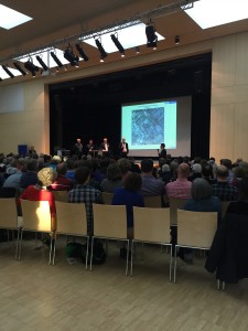
On April 7th, 2016, GEO-C in Muenster attended the public event of Oxford Barracks which was held by the city council of Muenster in Stein Gymnasium at Münster, Germany. This event was a dialogue between urban planners and citizens about an urban design for the zoning change of Oxford Barracks. Around 300 citizens attended this event.Lord Mayor Markus Lewe also attended the event.

Professor Joachim Schultz-Granberg, who was representative of the urban design team, gave a presentation in this event. He reported an insight into ongoing work on the planning of Oxford Barracks. The event also served as early public participation in the planning for the purpose of Building Code, after the city council decided the establishment of the necessary development plan and the zoning change.

We carried a survey during the event by handing out questionnaires. The aim of

DU_Mayor_Lewethis survey was to collect background information of public participation in urban planning process. As a result 100 questionnaires and 30 email addresses from attendees were collected. We got the final survey results by analyzing questionnaires and sent them to citizens who gave their email addresses. Here is a short summary of the main survey facts:

  1. Being informed, and the willingness to have a say were the most important interests of our sample with respect to participation in planning processes
  2. Most of the people surveyed would like to use online surveys (or alternatively public events) to express their opinions
  3. Local newspapers remain the most important information medium as regards planning processes, followed by the Internet page of the Münster City Council
  4. Newsletter is the most mentioned technological option when asked about what method would facilitate their participation in planning processes
  5. Citizens expect more transparency and openness in urban planning process.

A pdf file with the final survey results is available here: http://www.geo-c.eu/results#surveys

Short Paper accepted for presentation @ UCAmI2016!

The paper with the title “Toolkits for Smarter Cities: A brief Assessment” (Authors: Auriol Degbelo, Devanjan Bhattacharya, Carlos Granell, Sergio Trilles) has been accepted for presentation at the 10th International Conference on Ubiquitous Computing and Ambient ?Intelligence UCAmI 2016!

Abstract: The literature has offered a number of surveys regarding the concept of smart city, but few assessments of toolkits. This paper presents a short analysis of existing smart city toolkits. The analysis yields some general observations about existing toolkits. The article closes with a brief introduction of the Open City Toolkit, a toolkit currently under development which aims at addressing some of the gaps of existing toolkits.